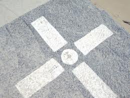
Aerial Photography and Mapping are when points are established on the ground, panel material is laid using coordinates and aerial photography crews fly over gathering the information.

This service is for those large, hard to reach jobs it can be a more cost effective way of gathering information about the topography of terrain.

Professional Land
Surveying Service

  • Establish control points on ground for aerial photography crew
  • Provide coordinates of points for aerial photography crew

surveys aerial, panel points, aerial photography

aerial survey panel points

Panel Point for ground elevation

Property Owner Benefit

  • Saves money and substantially reduces time of land survey crews in large projects